Wildfire management faces a persistent challenge: characterizing fuel loads across thousands of acres. Traditional ground-based fuel assessments are time-consuming as they require personnel to walk the site. They are also often spatially incomplete due to the tedious task of mapping such large areas. LiDAR-based canopy analysis is highly accurate, but requires specialized aircraft, high cost sensors, and processing expertise that many land management agencies cannot access at scale. Advances in drone-based photogrammetry and computer vision offer a compelling middle path that is operationally deployable and cost-effective for fire spread and suppression planning.
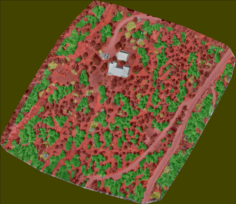
The Fuel Assessment Problem
Effective wildfire spread modeling depends on accurate characterization of three fuel conditions: ladder fuel, standing dead tree density, and horizontal understory spacing. Spacing and standing dead are largely inferable from nadir (straight-down) imagery. However, ladder fuel continuity, the sub-canopy structure that connects surface fuels to the crown, is difficult to assess from straight-down imagery alone. These conditions drive the fire pathways that determine when a surface fire transitions to a crown fire. This is the primary mechanism behind catastrophic wildfire behavior.
Ladder fuels such as shrubs, small trees, and low branches connect ground-level fuels to the forest canopy. These are largely invisible from directly above. An orthophoto, however detailed, shows only the top surface of the canopy. The sub-canopy conditions that determine whether a fire climbs from the ground to the crown are hidden beneath it. This is the core limitation that any orthophoto based fuel assessment system must confront directly.
Why Nadir Imagery Falls Short
Standard drone survey workflows produce dense digital surface models (DSM) through photogrammetry using Structure from Motion (SfM) techniques. These outputs are great for canopy height estimation and crown cover mapping, but they fail to capture what is happening beneath the tree canopy.
At nadir, every pixel in the reconstructed orthophoto represents the highest visible surface at that ground location. Tree crowns occlude the understory completely. No amount of increased image resolution, flight density, or SfM processing refinement changes this fundamental constraint. If the camera never sees the ground beneath the canopy, the reconstruction never will either.
Some may question, does Gaussian splatting or other novel view synthesis techniques close this gap? The honest answer is no. Gaussian splatting and Neural Radiance Fields (NeRF) are interpolation and synthesis methods. They generate plausible novel views of scenes they have observed, but they cannot accurately reconstruct regions that were never captured in the input imagery. Applying novel view synthesis to a nadir-only dataset produces visually compelling fills beneath canopy, but those fills are hallucinated from crown texture, not actual observations of understory conditions. The model will learn to classify the hallucination, not the fuel. This is unacceptable in safety critical applications.
Oblique Imagery as the Solution
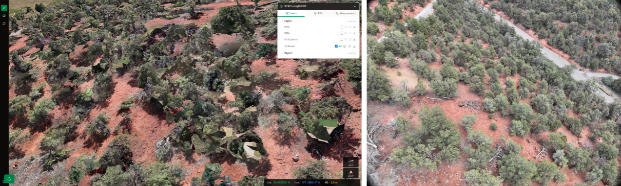
This problem has a geometric solution. By capturing imagery at oblique angles, usually 45° from nadir, the camera looks beneath the canopy edge, capturing the sub-canopy space where ladder fuel conditions are visible. A single oblique frame at the correct orientation and altitude reveals trunk spacing, brush continuity, and branch architecture that nadir imagery cannot see.
Modern survey drones support simultaneous nadir and oblique capture in a single flight, collecting oblique frames at multiple gimbal orientations alongside the standard nadir pass. At 30 m AGL with the onboard camera, oblique frames resolve individual branches, ground debris, and ladder fuel structures at the image center. At these resolutions, sub-canopy fuel conditions are clearly legible.
The challenge shifts from data collection to data exploitation. How do you train a model on oblique imagery, and how do you project predictions from the camera's perspective onto a geographically registered output map?
The AI Classification Pipeline
The classification pipeline consists of four stages operating on a per-site basis.
Data collection and preprocessing. A single drone flight collects both nadir frames (for orthophoto and DSM generation via ODM) and oblique frames at multiple azimuths.
Human annotation on raw oblique frames. Annotations are made on oblique images directly in a polygon-based annotation tool. Labeling on the raw frame, rather than on a rectified or warped derivative, preserves the full visual resolution and the natural perspective that makes sub-canopy fuel conditions legible.
Segmentation model training. A convolutional architecture processes the oblique RGB imagery and produces per-pixel class predictions with associated confidence scores. The model is trained on tiled oblique frames at native resolution. The nadir classification path additionally uses co-registered terrain features derived from the DSM, namely slope and local relief, which provide structural context that correlates with fuel accumulation patterns.
Projection and fusion. Rather than treating each prediction as if it lies on the ground, predictions are projected onto the dense reconstruction the photogrammetry pipeline produces from the full image set, nadir and oblique. Where the oblique frames observe beneath the canopy edge, this reconstruction captures real sub-canopy geometry rather than an assumed flat surface. Each labeled pixel is associated with the first reconstructed surface its ray intersects, so labels never attach to a point behind an occluder. Its class label and confidence are mapped onto that point in a three-dimensional voxel grid. When multiple frames observe the same point from different azimuths, the predictions are fused by agreement across those look directions. A coverage map records how many independent azimuth directions contributed to each point. The labeled voxel grid is then aggregated to the orthophoto grid.
Outputs
The primary output for each site is a set of georeferenced rasters overlaid on the nadir orthophoto. A coverage map accompanies each classification raster to indicate the number of oblique azimuths that contributed to each cell. These are fused per reconstructed point and carried onto the orthophoto grid. Pixels observed from only one direction carry higher uncertainty than those observed from three or four distinct azimuths. This coverage information can be used to prioritize ground-truth verification efforts and to weight fuel model inputs appropriately in fire spread simulations. The combination of nadir-derived canopy structure and oblique-derived understory fuel characterization produces a more complete fuel picture than either data source alone.
In practice the three target conditions are not all derived from the oblique segmentation. Tree spacing and standing/downed dead are assessed from the nadir products: the orthophoto and DSM. Crown positions, bare standing-dead crowns, and downed material in open areas are directly visible from above. The oblique capture is reserved for the one condition nadir cannot resolve: ladder fuel in the sub-canopy. The per-pixel oblique segmentation therefore feeds the ladder-fuel layer, while the spacing and standing-dead metrics are computed from the nadir orthophoto and DSM.
Current Limitations
The approach carries real limitations that should be understood before operational deployment. Sub-canopy coverage is inherently constrained by oblique viewing geometry. Dense canopy stands limit the depth of penetration at any given angle, and some understory conditions remain partially occluded even with multi-direction oblique coverage. The coverage map makes these gaps explicit rather than hiding them behind extrapolated predictions.
Model performance is currently bounded by labeled training data, which requires experienced fuel assessment personnel to annotate. Expanding the labeled dataset across diverse fuel types, geographic regions, and seasonal conditions is the primary path to improved generalization. Transfer learning from existing nadir-trained models can accelerate this process for new sites, but oblique-specific training data remains essential for the sub-canopy classification task.
The accuracy of this approach is bounded by what the photogrammetry pipeline reconstructs beneath the canopy: in dense closed-canopy stands few sub-canopy points may be recovered, and labels falling on unreconstructed regions revert to a less certain surface projection. Registration also depends on camera pose. The captures in our use case use RTK GNSS positioning, and weaker pose estimation would degrade both the reconstruction and the projection proportionally.
Tell us what you are fielding.
Field testing, data collection, and integration for emerging technology.
Book a 30-minute call